Event
Our institute is happy to be part of the NASA Space Apps Challenge - the world's largest mass collaboration, inspiring creative minds of all backgrounds & skill levels to tackle real-world problems using space data, both on Earth and beyond!
Event
online
Be part of the exciting launch of WorldCereal's advanced processing system for field-scale cropland and crop type mapping. Join our webinar on October 17, 2024, to explore the WorldCereal cloud-based processing system, the Reference Data Module, the possibilities to train and implement crop type models and future extensions.
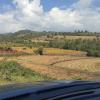
SAbERES: Supporting climate change adaptation for small-scale producers in Mexico
Article: News
02 September 2024
An IIASA-led paper published with collaborators and stakeholders from the Ghana Statistical Service, the United Nations Environment Programme (UNEP), SDSN TReNDS, and other partners has received the Outstanding Article Award in the journal Sustainability Science’s Best Paper Awards for 2023.
Article: Blog Post
29 August 2024
IIASA researcher, Linda See, shares her experiences at the coalface of where plastic pollution is collected by volunteers during a beach cleanup event.
Event
IIASA, Wodak Room
The Systemic Risk and Resilience Group in ASA will host this year's workshop at IIASA on "Social Capital and Development Trends of Countryside in Knowledge and Risk Society".
Article: News
22 August 2024
To address the needs of the agricultural monitoring community, IIASA scientists fused two of the latest high quality, high-resolution, remotely-sensed cropland products to produce an improved cropland map for early warning and food security assessments.
Event
Frascati, Italy
The URBIS24 Workshop will gather a diverse community of urban policymakers, Earth Observation researchers, service providers and various end-users. Taking place at ESA/ESRIN in Frascati, Italy, during September 16–18, 2024, this event will offer an insightful exploration of urban challenges and innovative EO-integrated solutions.
Event
Vienna, Austria
The ESA Living Planet Symposium 2025 on Earth observation will be held in Vienna, where numerous colleagues from the NODES research group will be actively participating.
Event
Krakow, Poland
Research Scholar Steffen Fritz at the EuroGEO conference.
Article: News
17 July 2024
Despite facing regional threats like deforestation and wildfires, the world's forests continue to be a powerful weapon in the fight against climate change. A new study reveals these vital ecosystems have consistently absorbed carbon dioxide for the past three decades, even as disruptions chip away at their capacity.
Article: Blog Post
08 July 2024
The Gambia faces significant food availability issues due to low agricultural productivity. IIASA researchers and colleagues used the FABLE Calculator to explore actions to reduce the food supply-demand gap by 2050. The results, published in Food Security, reveal that current cropland will not meet food demand by 2050.
Article: News
01 July 2024
A new publication authored by scientists from the German Centre for Integrative Biodiversity Research (iDiv) and IIASA with a large European consortium provides vital insights into the current status of biodiversity monitoring in Europe, identifying policy needs, challenges, and future pathways.
Article: Other
27 June 2024
Working with IIASA researchers, Ghana pioneered the adoption of a citizen science approach to address the problem of plastic pollution in marine environments. Further analysis highlighted how a similar citizen science data validation and reporting process can benefit reporting on the Sustainable Development Goals (SDGs) in other countries.
Article: News
26 June 2024
Computer games are not only entertaining but can also offer new perspectives, as demonstrated by the game "Climate Survivors". In this game, players combat the consequences of global warming while learning about scientifically grounded facts in an engaging and playful way.
Article: News
14 May 2024
Discussions around soil carbon have traditionally revolved around organic matter, overlooking the substantial contribution of soil inorganic carbon. A recent study published in Science by an international team of researchers, however, addresses this oversight.
Event
Smithsonian Institution in Washington, DC
GEO-TREES Launch Workshop at the Smithsonian Institution in Washington, DC during 15-17 May 2024.
CROPS – Curating, Replicating, Orchestrating, and Propagating Citizen Science across Europe
Global Pasture and Livestock Monitoring
Event
Tallinn, Estonia
The Biodiversa+ Science-Policy Forum held in Tallinn on April 16, 2024, aimed to assess the current status of biodiversity monitoring at various scales and foster dialogue between knowledge providers and policymakers.