
IIASA is partnering with CIFOR-ICRAF and WRI to gather CSOs, businesses, sub-national government agencies and IPLC representatives in establishing an open-source initiative to strengthen land use intelligence for nature-based climate solutions (NCS) in Indonesia and Southeast Asia. This initiative, called Epistem, develops interoperable digital platforms that improve the availability and usability of land use and land cover (LULC) data for planning, implementation and monitoring of ecosystem interventions that deliver climate, biodiversity and livelihood outcomes.
 © IIASA
Indonesia and Southeast Asia contain extensive tropical forests, peatlands and biodiversity-rich landscapes with significant mitigation potential. These ecosystems are central to climate resilience and rural economies. Realizing this potential requires reliable high-resolution LULC data. Such data underpin spatial planning, inform investment decisions, support policy compliance and enable effective monitoring, reporting and verification systems. In many contexts, access to timely and locally relevant information remains limited. This constrains accountability and scalability and reduces the effective integration of co-benefits, including carbon sequestration and equitable land governance.
Many global LULC products do not adequately capture under-the-canopy conditions such as shaded agroforestry systems, stratified forest structures and secondary vegetation. As a result, they may overlook ecologically and socially important land uses. By enabling user-defined land classes and strengthening ground-truth data, Epistem improves the thematic relevance and contextual accuracy of LULC maps.
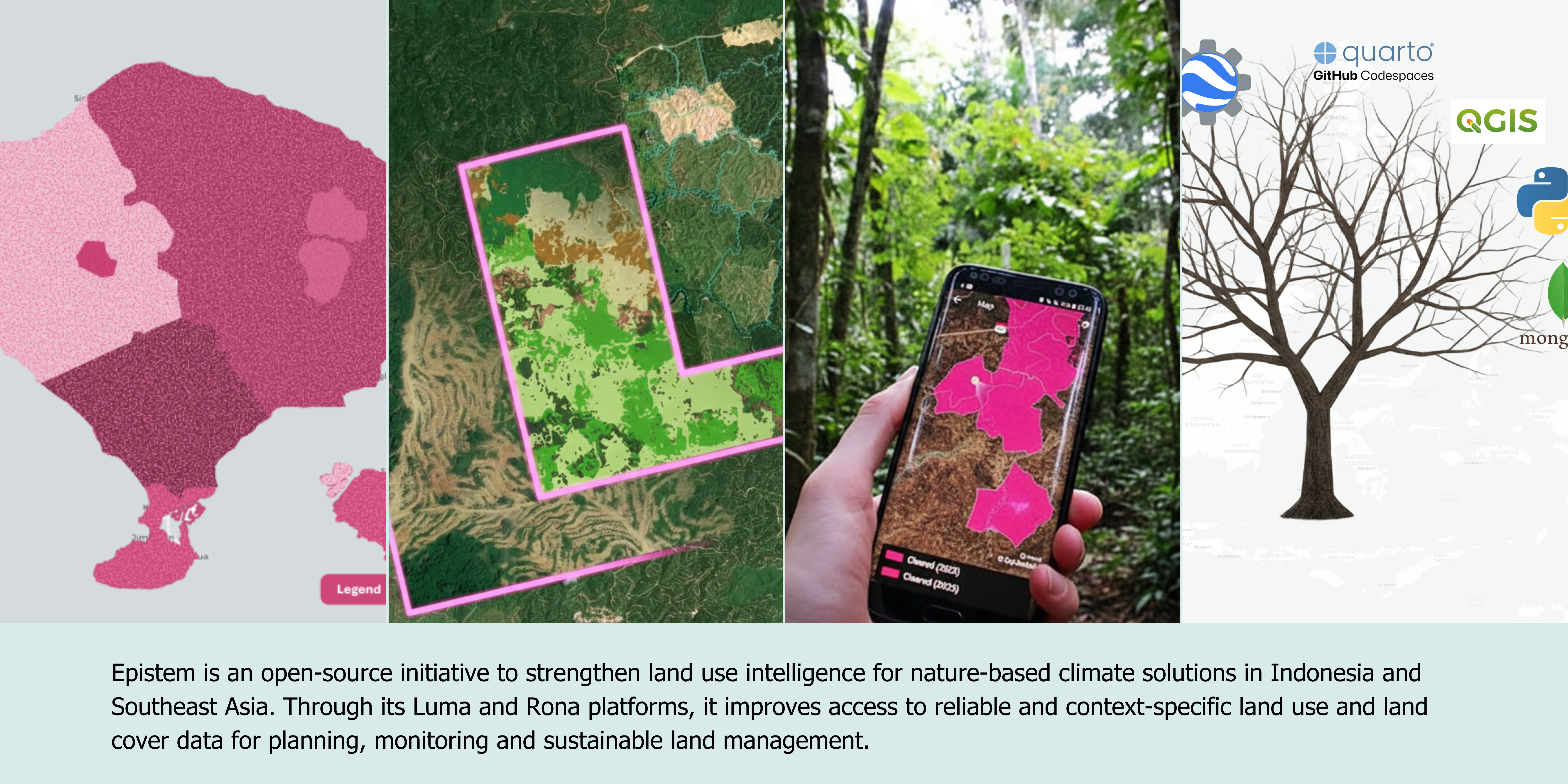
To address these challenges, Epistem aims to provide two complementary platforms. Luma (Land Use Mapping for All) enables users to generate customized LULC maps from publicly available satellite imagery through an intuitive, no-code workflow. Users define land classes that reflect specific intervention objectives and produce maps suitable for sustainable land management. The platform supports consistent change detection over time and comparative analysis between landscapes.
Rona (Repository for Open-source laNd use Analysis) complements Luma by providing a structured and scalable repository of high-quality reference data. The platform integrates expert-annotated satellite imagery with curated field datasets and enables structured crowdsourced validation and cross-verification. This strengthens ground-truth information, improves classification accuracy and supports transparent data stewardship across Southeast Asia.
The platforms have been co-developed from the outset with national and subnational stakeholders in Indonesia, including the Ministry of Environment and Forestry, the National Research and Innovation Agency (BRIN), local governments, universities and civil society organizations. Implementation is being tested through pilot applications in peatland restoration in South Sumatra, upland forest management in South Sulawesi and dryland ecosystem interventions in East Nusa Tenggara. These pilots ensure contextual relevance in diverse socio-ecological systems and support scalability throughout Indonesia’s varied landscapes.
Epistem’s activities in Southeast Asia are complemented by related work in Brazil under the second phase of the RESTORE+ project. This work advances open-source forest monitoring tools, improvements to the Rural Environmental Cadastre, and long-term AFOLU emissions scenario development. Together, these efforts strengthen national capacity for deforestation tracking, restoration enforcement and Paris Agreement–aligned land-use strategies, demonstrating the broader applicability of participatory and open-source land data systems for scaling nature-based climate solutions.
Partners:
- International Centre for Research in Agroforestry (ICRAF)
- World Resources Institute (WRI) Indonesia
- Associação de Especialistas Latinoamericanos em Sensoriamento Remoto (SELPER Brazil)
Epistem Team

Ping Yowargana
Senior Research Scholar (AFE)

Bestari Ghea Dwilo
Project Officer (AFE)

Gautam Dadhich
Researcher (AFE)

Maria Adelia Widijanto
Researcher (AFE)
Events
Majapahit Room, A. A. Maramis Building, Jakarta, Indonesia