IIASA, the United Nations Industrial Development Organisation, and the Global Environment Facility have launched an interactive online mapping tool that allows the public and policymakers to easily explore overlapping and interconnected climate risks around the world.
A new interactive website, the Global Hotspots Explorer brings to light the multi-sectoral climate risks faced by many regions of the world. IIASA researchers presented the tool to partners at the United Nations Industrial Development Organisation (UNIDO) today.
UNIDO plans to use the tool during the project development stage to identify climate risks when developing projects for countries within the remit of their development work.
“The Global Hotspot Explorer could be the perfect interface between scientific evidence and research related to climate impacts and its tailored integrated interventions from a development perspective,” says Robert Novak, an Industrial Development Officer at UNIDO who was involved in the project.
The Hotspots Explorer was developed as part of the Integrated Solutions for Water, Energy, and Land (ISWEL) project, which started in 2017. The ISWEL project, a partnership between IIASA, UNIDO, and the Global Environment Facility (GEF) explored the intersections of climate impacts across water, energy, and land, sectors that in large part had previously been addressed in a siloed manner. Including both regional case studies and a global analysis that led to the hotspots research, the aim of the project was to produce actionable results that international organizations and development agencies could use to inform investment and development strategies that lead to the best possible outcomes for vulnerable populations.
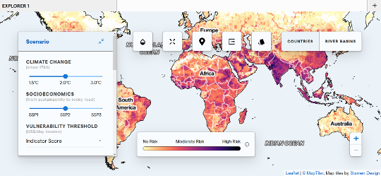
The hotspots explorer makes easily accessible in-depth research from the ISWEL project, which has been published in several peer-reviewed journal articles and included as part of the Intergovernmental Panel on Climate Change (IPCC) Special Report on the impacts of global warming of 1.5°C. Easily navigable, the website allows users to explore multiple climate risks under various future climate change scenarios. The aim of the website is to provide overview and opportunities for rapid comparison, as opposed to very detailed impact information in specific locations, such as cities.
“The aim of the hotspots work was to pinpoint locations facing multiple climate change impacts and locations where people are extremely vulnerable, because that would be where you could be most effective if you target your resources in those locations,” explains Edward Byers, a researcher in the IIASA Energy Program.
For example, if you live in a region that is subject to drought, climate change may increase the risk of drought, but if your region also experiences flooding, crop failure, or intense heat waves, your risk to climate change impacts is compounded.
“We designed the website to allow users to quickly evaluate and compare climate risks between regions, countries and river basins across the world. The framework includes 14 hazards, such as drought intensity, water stress, heatwaves, crop yield change, and habitat degradation,” says Byers.
 © © MapTiler, Map tiles by Stamen Design
Global Hotspots Explorer - Leaflet
Hazards are categorized by water, energy, and land sectors, and users can easily compare scenarios from low (1.5°C) to high (3.0°C) climate change, as well as different levels of development – critical for evaluating the vulnerability of a population and their ability to cope with climate impacts.
Users can download data and the results are backed up by an ensemble of state of the art climate, hydrological, and integrated assessment models.
Reference:
Byers E , Gidden M, Leclere D, Burek P , Ebi KL, Greve P, Grey D, Havlik P, et al. (2018). Global exposure and vulnerability to multi-sector development and climate change hotspots. Environmental Research Letters 13: e055012. DOI:10.1088/1748-9326/aabf45.
News

28 June 2024
Drowning in waste: pollution hotspots in aquatic environments

27 June 2024
What can social media tell us about public views on climate change?

21 June 2024

