

GEO-OPEN-HACK-2024 is a comprehensive and informative event designed for advanced geo-coders to explore various open tools and approaches for upscaling geospatial analysis on open High-Performance Computing (HPC) infrastructure.
The event is organised by the International Institute of Applied Systems Analysis (IIASA) in collaboration with Spatial Ecology. This hackathon delves into advanced cutting-edge open techniques, tools, and best practices for efficiently handling and processing vast amounts of geospatial data. Participants will gain hands-on experience in leveraging HPC resources and geo-tools for tasks such as geospatial data preprocessing, spatial modeling and analytics, and visualization.
Hackathon highlights
- Introduction to Big Geospatial Data: Understanding the challenges and opportunities presented by large-scale geospatial datasets.
- High-Performance Computing Basics: Familiarization with HPC systems, queuing system, parallel processing, and optimization techniques
- Open Tools and Workflows: Techniques and tools for geospatial data processing and spatial analytics for applications like remote sensing, GIS, and environmental change monitoring.
- Modern Geo-analytics: Exploring emerging trends and technologies in the field, such as machine learning and cloud-based geospatial analytics and visualization.
- Parallel Computing: Harnessing the power of parallel and distributed computing for speed and efficiency for geospatial analysis.
- Performance Tuning: Strategies to optimize ML models and workflows for HPC environments.
- Case Studies: Real-world examples of successful big geospatial data projects on HPC systems.
- Scalability and Big Data Challenges: Addressing issues related to data volume, velocity, variety, and veracity in geospatial analysis.
 © IIASA
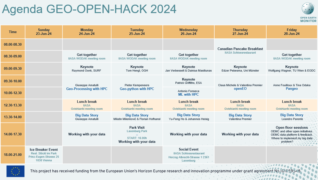
Keynotes
Monday, 9.00-9.30 am
- HPC and current European developments: European data spaces, EuroHPC, and DestinE; Raymond Oonk, SURF (Collaborating University Computing Facilities), The Netherlands
Tuesday, 9.00-9.30 am
- Open Earth Monitor Cyberinfrastructure (OEMC): modern open source solutions for HPC and open science; Tom Hengl, OpenGeoHub Foundation, The Netherlands
Wednesday, 9.00-9.30 am
- Evolution of BFAST functions for characterizing land change using satellite image time series; Jan Verbesselt, Belgian Science Policy Office, Belgium & Dainius Masiliunas, Wageningen University, The Netherlands
Wednesday, 9.30-10.00 am (remote)
- Streamlining operationalisation of EO based solutions for the Green Transition using interoperability best-practices; Patrick Griffiths, European Space Agency, Italy
Thursday, 9.00-9.30 am (remote)
- openEO: open science for Earth Observation compute platforms; Prof. Edzer Pebesma, Münster University, Germany
Friday, 9.00-9.30 am
- Global scale analysis of Sentinel-1 satellite data at the Earth Observation Data Centre; Prof. Wolfgang Wagner TU Vienna & Earth Observation Data Centre GmbH, Austria
Big Data Stories
Monday, 13.30-14.00
- Global Flow Discharge: Modeling Upper Stream Contribution with a ML Feamework; Giuseppe Amatulli, Yale University & Spatial Ecology, USA
Tuesday, 13.30-14.00
- Citizen Science Mobile App for Measuring Trees; Milutin Milenković & Florian Hofhansl, The International Institute for Applied Systems Analysis, Austria
Wednesday, 13.30-14.00
- Accessing Big Vector Data on the cloud using Arrow Parquet; Yu-Fend Ho, OpenGeoHub Foundation, The Netherlands & Johannes Heisig, Münster University, Germany
Thursday, 13.30-14.00
- Leveraging Satellite Data for High-Resolution Snow Monitoring: Scaling with openEO; Valentina Premier, Eurac Research, Italy
Friday, 13.30-14.00
- Optimizing Global Time Series ML Predictions: From Modeling to Production Deployment; Leandro Parente, OpenGeoHub Foundation, The Netherlands
Hackathon requirements
This is an advanced-level hackathon, ideal for early-career researchers, scientists, and professionals interested in unlocking the full potential of big geospatial data by harnessing the computational power of open HPC systems. Participants will leave with valuable insights and practical skills to tackle their geospatial challenges at scale.
The hackathon is aimed at individuals with masters or doctoral qualifications. It will provide them an opportunity to scale-up their own spatio-temporal modeling and data analysis projects. Hackathon participants should have intermediate bash and Python skills, basic ML-python knowledge, and a strong desire to learn command line tools for massive geo data processes. R users are also welcome if they feel comfortable with command line operations in bash and python environments.
Basic concepts of GIS, such as familiarity with rasters/vectors, overlays, buffering etc, and basics of statistics, such as mean standard, deviation, residuals, as well as python and bash syntax will be assumed as given. We will share tips and tricks on massive data processing, and therefore a strong bash and Python base will be essential grasping nuanced concepts that can boost your geo-analysis.
A developer committee will evaluate the pre-registration assessment and select 25 applicants on one of the following criteria:
- Applicant’s git repository (Github, Gitlab, Bitbucket) for an evaluation. The following will be assessed:
- Use of Python code and bash (including GDAL) for txt and geo-data analysis. Laptop-executed scripts are sufficient, i.e. no need to demonstrate code for cluster processes.
- Use of scikit-learn python (or similar library) for ML applications, in other words we want people that think in a multidimensional way.
- Any evidence of bash and Python used by advanced R programmers, e.g. Git repositories, coding samples or relevant course certificates etc. Moreover fundamentals of ML are also needed.
- Completion of the “Geocomputation & Machine Learning for environmental applications” course and workshop organized by Spatial Ecology
Registration information
- On-site registration fee 200 Euro
- Online registration fee 50 Euro
This is a not-for-profit event, and registration fees serve only to cover hospitality costs (social events, lunches, coffee breaks, etc.). Accommodation and travel costs are the responsibility of the participants.
Online participants will be able to ask questions and receive live assistance by a course instructor. However, troubleshooting will be limited due to logistical constraints. Lectures will be recorded and made available for asynchronous viewing, allowing participants in distant time zones to participate as well. Links to the recordings will be shared only with those who register as online attendees.
To register, all participants must:
- Complete the skills assessment and the pre-registration form
here. - closed - Wait for our approval before proceeding with fee payment.
- Pay the registration fee.
You will be considered registered only when we have received your completed pre-registration form, and we have sent you a confirmation email, and the registration fee has been paid in full.
The pre-registration form will be open until March 31. 2024.
Payment information: the payment options are explained here. Please wait first to receive the approval (see step 2 above). The deadline to pay the registration fees is until May 15. 2024.
Refund policy: A written request for registration cancellation must be e-mailed to the hackathon organizers. If registration cancellation is requested by April 30. 2024, the full registration fee will be refunded. If a cancellation request is submitted after April 30. 2024, we will retain 80% of the fees unless a candidate from the waiting list is able to replace the withdrawing candidate.
Visa requirements: On-site participants are responsible for ensuring they have the correct documentation to enter Austria. Please check your visa requirements and visa issuance waiting times, ensuring that you are able to travel to Austria on a Schengen visa in time for June 2024. Check here for countries that need a Schengen visa. Please note that the hackathon organizers are not authorized to assist with the VISA process beyond providing the Invitation Letter.

Teachers and supervisors
Giuseppe Amatulli - Yale University, US; Spatial Ecology, UK
Antonio Fonseca - Yale University, US; Spatial Ecology, UK
Anne Fouilloux - SIMULA, Norway
Tina Odaka - CNRS-Ifremer-IRD-UBO, France
Pieter Kempeneers - JRC, Italy
Francesco P. Lovergine - CNR-IREA, Italy
Michele Claus - EURAC, Italy
Valentina Premier - EURAC, Italy
Tom Hengel - OpenGeoHub, The Netherlands
Leandro Parente - OpenGeoHub, The Netherlands
Yu-Feng Ho - OpenGeoHub, The Netherlands
Dainius Masiliunas - WUR, The Netherlands
Johannes Heisig - Münster University, Germany
Milutin Milenković - IIASA, Austria
Scientific Advisory Panel
Steering Committee
Milutin Milenković - IIASA, Austria
Giuseppe Amatulli - Yale University, US; Spatial Ecology, UK
Tushar Sethi - Spatial Ecology, UK
Acknowledgments
 © EU
© EU
GEO-OPEN-HACK-2024 is an initiative under the Open-Earth-Monitor Cyberinfrastructure (OEMC) project aiming to lower the barrier and transfer knowledge to users dealing with big geospatial data analytics. The OEMC has received funding from the European Union's Horizon Europe research and innovation programme (grant agreement No. 101059548). GEO-OPEN-HACK-2024 is also an initiative in the framework of NSF-funded POSE project TI-2303651: Growing GRASS OSE for Worldwide Access to Multidisciplinary Geospatial Analytics.
Upcoming Events
Segovia,Spain
Climate Change and Insurance Workshop 2026 (CCI26)
Royal Belgian institute of Natural Sciences, Rue Vautier 29, 1000 Bruxelles, Belgium
The Final Event of NaturaConnect: Pathways to a Trans-European Nature Network
Barcelona, Spain
Open Earth Monitor Final Workshop 2026
Barcelona, Spain
ENFORCE Annual Project Meeting
Chulalongkorn University, Thailand
Training workshop: Demographic analysis with applications to aging, health, and education
Beijing, China
Overshoot Conference 2026
IIASA, Laxenburg, Austria