


Although many policymakers might still not realize it, disasters like floods, hurricanes, or earthquakes are not isolated events. Their impacts can spread much wider, disrupting power supply, cutting off roads, or even worse – delaying logistics and your next Amazon delivery by weeks. The latest deliverable in the PARATUS Project sets out to build a clear methodology for assessing systemic risks across the case studies chosen earlier in this project.
IIASA developed new methods to handle uncertainty – using statistical and machine learning models to fill data gaps, and downscaling techniques to bring coarse projections (like national population growth) down to the level of individual neighborhoods. Decision-makers can now choose alternative storylines, such as a “business-as-usual” path that continues old habits or a “risk-averse” path that allows development to actively avoid hazard-prone areas. Different stakeholders are now able to test strategies before committing to them.
Now let’s look at the four different case studies examined by the PARATUS project.
Bucharest is no stranger to earthquake risk; many of its historic buildings could collapse in the event of a major quake. While previous studies only highlighted this danger, PARATUS goes a step further. The latest deliverable introduces a scenario-based approach. IIASA and its partners can now project Bucharest’s vulnerability under different improvements, such as stricter building codes, retrofitting programs, or even population relocation. Using statistical and machine learning models allows decision-makers to test policies before disaster strikes.
Istanbul faces a similar challenge as Bucharest – a dense, aging building stock that is prone to even moderate earthquakes. This can seriously disrupt the logistics of transport and industry. IIASA plays a central role in addressing this issue with its Vulnerability Analysis and Assessment (VAA) tool. It shows how vulnerabilities shift under different future pathways. Questions such as “What happens if new housing is built far away from high-risk zones?” or “How does access to open spaces change resilience?” can soon be answered by IIASA and its partners. With this new tool, policymakers can move beyond static maps of risk and steer Istanbul’s future development toward safer ground – literally.
Although many people see the Brenner Pass as a scenic Alpine crossing, it is far more than that. More than two million trucks use this north–south corridor to transport goods, not to mention millions of private vehicles traveling through one of Europe’s busiest routes. Any disruption can cause severe supply chain breakdowns and economic losses across the continent. Together with partners such as ASFINAG, IIASA combined real-time traffic and weather data while also considering long-term climate projections using the VAA tool. Austrian and Italian authorities can now test measures before implementing them, such as stricter traffic restrictions or safety retrofits.
For Caribbean communities, it has become a sad reality to know how to rebuild homes, ports, and livelihoods after major hurricanes and floods. Until now, risk assessments have mostly been snapshots showing the existence of hazards. Using the VAA tool, IIASA has helped design dynamic vulnerability scenarios that link climate projections with socioeconomic aspects such as housing or tourism. Caribbean islands like Saint Vincent and Sint Maarten can now anticipate cascading risks – before the next hurricane season begins.
News
03 July 2026
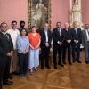
Building bridges: Indian Ambassador visits IIASA
H.E. Ambassador Shambhu S. Kumaran, India's Permanent Representative to the International Organizations in Vienna, recently visited IIASA to explore deeper research cooperation and meet the Institute's Indian Young Scientists Summer Program (YSSP) cohort.
03 July 2026
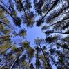
Tree-Quest: a citizen science tool for collecting single-tree information
Tree-Quest is a citizen science mobile tool that enables users to measure aboveground biomass related attributes (tree diameter, height and species) and estimate carbon stored in trees while contributing data for forest and urban tree mapping, supporting research on biomass and carbon storage. Engaged citizens can measure nearby trees in their local surroundings, such as parks and along the streets in urban areas, integrating science into their daily routines. This helps generate valuable ground-based observations on trees in urban environments that can be used for satellite-based carbon assessment.
02 July 2026
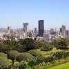
IIASA welcomes delegation from the National Research Foundation South Africa
A delegation from South Africa's National Research Foundation (NRF) visited IIASA to exchange knowledge on systems approaches to disruptive change, innovation, and evidence-informed decision-making. The visit reflects the longstanding collaboration between IIASA and South Africa.