The main objective of the World Ecosystem Extent Dynamics project is to develop and showcase a versatile and globally applicable innovative toolkit that utilizes Earth Observation data to map and monitor their changes in extent for terrestrial, freshwater, and coastal (up to the intertidal zones) ecosystems.
The project aims to enhance skills and knowledge through country demonstrations in close collaborations with national authorities, both in Europe and worldwide. It will liaise with international efforts an initiatives to support multiple policy frameworks, such as CDB Global Biodiversity Framework, SEEA Ecosystem Accounting, Ramsar, SDG's and Paris agreement on Climate.
Main objectives of the project:
- To develop a globally applicable open-source toolbox, leveraging existing datasets and tools while applying creative and novel methods to use Earth Observation, to enable users to generate comprehensive maps of the extents of terrestrial, freshwater and coastal ecosystem types and their temporal variations according to different ecosystem typologies.
- To integrate the toolbox in an easy-to-use end-to-end cloud-based processing system, developed according to the FAIR principles and in compliance with interoperability standards. The toolbox will be able to deal with the variability of data sources, and differences in the technical capacity of the users.
- To develop the toolbox in collaboration with users, while liaising with key international initiatives and key international stakeholders. The toolbox is considered as a contribution to international efforts to map ecosystem extent, e.g., GEO Ecosystem Atlas, CEOS EETT, etc.
- To demonstrate the robustness and transferability of the toolbox and its system to scale to larger areas (national and European scale) and showcase the use of its results (maps and tables) for policy applications.
The four objectives together should result in an increase of the acceptance and adoption of EO-based solutions for ecosystem extent mapping and their dynamics in national practices and solutions.
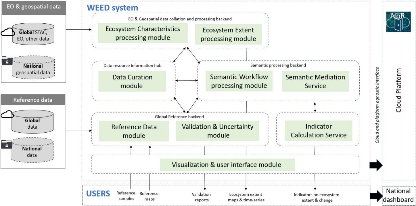
Overview of the WEED Sytsem
The project will be carried out in two phases. In Phase I, we will collaborate closely with six Champion users from Europe, Africa, Asia, and Latin America. In several Living Labs, we will synthesize user requirements and associated risks to ensure that the developed tools will be respectful to national contextual specificities and have direct applicability in national monitoring systems and reporting requirements.
In Phase II, we will work with the six Champion users and five additional countries on a series of national and European ecosystem-mapping and ecosystem-change-detection exercises, to demonstrate the robustness, transferability, and scalability of the WEED system. Furthermore, we will reach out to several additional stakeholders via face-to-face meetings and webinars to promote the appropriation of the WEED system in operational ecosystem mapping and monitoring systems. To this end, we will develop training material and promotional packages, in addition to scientific publications.
The NODES Research Group at IIASA is a core partner in the project, responsible for designing and developing the approach to in situ reference data collection, incorporating new AI-assisted systems. Their tasks include updating the LACO-Wiki and WorldCereal reference data modules, establishing validation procedures for the WEED products, and coordinating the project's outreach efforts.
The consortium consists of multiple partners from 8 different countries, and champion users:
- Core partners - VITO, BC3, iDIv and IIASA,
- Thematic partners -DHI, Ecounting and JCU
- European champions users - NINA for Norway, CZU for Czech Republic, and University of Patras for Greece


