Juan Carlos Laso Bayas and colleagues reflect on the outcomes of the SATFARM Services project, which set out to create models that demonstrate the potential of satellite data to track climate-smart agricultural practices and visualize indicators to track their success in a prototype web platform for Austrian farmers.
How can I shield my agricultural production against climate change effects such as extended droughts? This is a question more and more farmers are asking themselves across the world. Policymakers on the other hand, wonder how they can get reliable information across large areas quickly to support farmers and promote policies that enhance farm resilience.
Every year we notice that in different regions of the world, including here in Austria, extreme weather events are becoming increasingly commonplace: droughts last longer and flood events happen more frequently, all as a cumulative result of the rising levels of greenhouse gases in our atmosphere. This in turn causes the climate to become more unpredictable and volatile, which often has terrible consequences for farms including affecting crops at critical moments and thereby drastically reducing yields, or the destruction of entire harvests.
Climate-smart practices are among our best options to adapt and protect global agricultural production in the face of climate change. These techniques can help crops survive and thrive under more extreme weather conditions by increasing the soil capacity to, for example, retain water and release it slowly in drought conditions. Complementarily, satellite data are becoming increasingly available and accessible and can be used to help both farmers and policymakers make better decisions. Nevertheless, to generate models that reliably connect remotely sensed information to farming techniques implemented on the ground, large amounts of on-farm information compiled from multiple years of observations are needed.
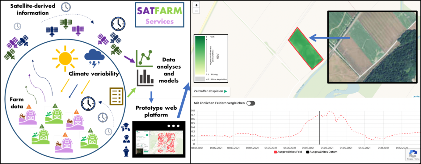
Over the last two years, my colleagues and I in the Novel Data Ecosystems for Sustainability Research Group (NODES) of the IIASA Advancing Systems Analysis Program, led a group of scientists and specialists from the University of Natural Resources and Life Sciences (BOKU) in Vienna, and Sentinel-Hub GmbH, a private company in Graz, in the SATFARM Services project, an Austrian Research Promotion Agency (FFG) funded effort. We set out to create models that demonstrate the potential of satellite derived agricultural indicators to track climate-smart practices and visualize these in a prototype web platform (currently only available to Austrian farmers who provided farm-level data due to privacy concerns). We were successful, and the prototype platform created now allows farmers and policymakers to visualize satellite-derived indicators for 10,000 land parcels in Lower Austria, as well as compare different parcels against each other. Most importantly, our models proved that this use of satellite information is not only possible but also needed.
The road to achieving this was long and challenging, as we integrated a large time-series farm data set provided by the Austrian Agricultural Chamber, with satellite-derived indicators such as the Normalized Difference Vegetation Index (NDVI), capable of showing crop health based on sunlight reflection captured by the satellite sensors.
The SATFARM Services project, linking farm data to satellite information and displaying these relationships on a prototype web platform
Some of the most critical challenges we faced included providing an accurate location (geo-reference) to each of the fields available on the farm-level data set, a task achieved by our partners at BOKU, as well as cleaning the data set afterwards, a task that we managed internally at IIASA. Since the farm data set presented information over many years (from 2002 onwards), one of the main issues was allocating the correct location information to changing areas, often also named differently over time, or containing data entry errors.
Once this step was achieved, we started to map and model the relationships we could find between remotely sensed indicators and the ground-registered practices to detect climate-smart practices. We focused on determining the pre-crop (previous year crop), sowing date, harvest date, and the existence or not of cover crops (i.e., plants used to slow erosion and improve soil health), which are four of the most common climate-smart agricultural techniques employed to adapt to climate change. They do that by helping to make the best use of soil humidity and fertility, for instance, by planting later than expected as a result of waiting for more rain. Our partners at Sentinel Hub VAS provided the satellite-derived indicators and assembled the platform with the models developed at IIASA.
The SATFARM Services journey included consultations with Austrian farmers, farmer organizations, local policymakers (regional and national), as well as international organizations such as the European Commission Joint Research Center (JRC), who guided our project to choose the best climate-smart practices and focus our efforts to produce a viable web prototype.
We are grateful to all the farmers and institutions that helped SATFARM Services succeed and we hope that the results presented will be valuable to the participating farmers and policymakers. We also invite any interested Austrian farmers who would like to contribute data to get in touch with our working group in the chamber of agriculture at https://noe.lko.at/arbeitskreis-ackerbau+2400+1648969 (website only available in German).
We continue to look for support to build on the experience we developed in this project and upscale the models, which will require much more local information, but will allow us to produce an open platform at the regional or European level. If you want to support or join the experience, please drop us a line! More information is available at https://boost.austria-in-space.at/project/satfarm/.
Note: This article gives the views of the author, and not the position of the Nexus blog, nor of the International Institute for Applied Systems Analysis.
