How can citizen-powered science coupled with mobile technology improve our understanding and governance of land use and land cover changes?
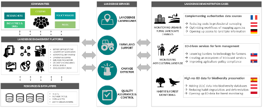
The LandSense project will build an innovative citizen observatory in the field of Land Use Land Cover (LULC), which collects data both actively (through citizens) and passively (from authoritative, and open access sources) and integrates them to provide valuable quality-assured in-situ data for SMEs, larger businesses, government agencies, NGOs and researchers. There is currently no single marketplace that brings together the growing demand for in-situ data for the monitoring of land use. LandSense will build such a marketplace to attract a vast community of users across numerous disciplines and sectors and thereby boost Europe’s role in the business of in-situ monitoring. LandSense will also provide multiple pathways for citizen empowerment that go beyond simple data collection by providing a range of engagement tools that will allow the voices of citizens to be heard.
The Earth Observation Systems group at IIASA is a pioneer in citizen science and crowdsourcing initiatives specifically in the field of LULC monitoring. As such, the LandSense Observatory will extend existing IIASA-led initiatives, such as Geo-Wiki, LACO-Wiki, Cropland Capture, and FotoQuest to create integrated solutions that conflate satellite data with citizen science to tackle key issues surrounding flood resilience, food security, and biodiversity conservation.
LandSense Objectives
Assess current practices, user requirements and barriers of present LULC technologies and illustrate the potential extension of such applications through the incorporation of in-situ citizen observatories
Engage key stakeholders in the LandSense platform, which facilitates the collection, integration, management, and contextualized presentation of LULC information
Deliver four innovative and scalable LULC services - LandSense Campaigner, Farmland Support, Change Detector, and Quality Assurance & Control - and implement a strategy detailing the sustainable exploitation of these technologies post-project
Demonstrate the quality, confidence and added value of in-situ citizen-driven observations for improved LULC monitoring through demonstration cases across Europe and beyond
Promote the uptake of the LandSense technologies, solutions, and products for large-scale LULC monitoring across Europe and beyond through the LandSense Services Incubator compromised of key stakeholders from various sectors
Concept
 © IIASA
Project partners
- International Institute for Applied Systems Analysis, Austria
- Birdlife International; UK
- Sinergise; Slovenia
- University of Nottingham; UK
- InoSens doo; Serbia
- GeoVille Information Systems GmbH; Austria
- Environment Agency Austria; Austria
- Institut National de l’Information Géographique et Forestière; France
- European Citizen Science Association; Germany
- StZ Felis; Germany
- University of Heidelberg, GIScience Research Group; Germany
- Wageningen University; The Netherlands
- VU University Amsterdam; The Netherlands
- Joint Research Centre; Italy
- Secure Dimensions; Germany
- Friends of the Earth/Global 2000; Austria
- European Crowdfunding Network; Belgium
Landsense Apps
- CityOases is a pilot project within the international project Landsense coordinated by IIASA and funded under the European Union's Horizon 2020 framework programme. The Landsense project has developed a citizen observatory and innovation marketplace for land use and land cover monitoring and runs various pilot projects in Europe, such as CityOases in Vienna.

