A model assessing how land management affects the environment
 © IIASA
EPIC Model
At IIASA, the EPIC-based global gridded crop modelling system “EPIC-IIASA” is used to assess the main global agricultural systems in response to management interventions such as cropping practices, fertilization and irrigation practices or conservation and organic agriculture options, and changing environment, including climate change and soil degradation. Furthermore, EPIC-IIASA is used to compare cropland management systems and their effects on environmental indicators like water availability, nitrogen and phosphorus levels in soil, and greenhouse gas emissions.
Building on the Environmental Policy Integrated Climate model and global or regional datasets on climate, soils, land cover, and land use, EPIC-IIASA can analyze numerous crop types and their management under different weather, topographical, and soil conditions. It investigates the trade-offs between plant growth and yield on the one hand, and environmental impacts and sustainability on the other.
For example, EPIC-IIASA can estimate—based on soil type and prevailing climatic conditions—the extent to which nutrients from fertilizer, such as nitrogen (N) are leaching into nearby river and stream networks. This problem is of growing concern as globally two-fifths of N used in agriculture is lost to ecosystems with harmful environmental effects.
EPIC-IIASA can analyze options of sustainable agriculture including soil erosion control, crop residue management, improving soil organic carbon stock and reducing GHG emissions. Global and regional EPIC-IIASA applications help informing on the potential of agricultural systems to contribute to meeting global climate and food security targets.
How the model works
EPIC-IIASA models a wide range of biophysical processes in the soil-plant-atmosphere system at large scales to consider alternative land uses where land is becoming degraded or is putting natural ecosystems at risk.
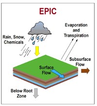
It includes a full water cycle, allowing the quantification of water availability for plant growth, surface water runoff and percolation downwards to the groundwater system. It can simulate effects of different weather patterns and events, such as heavy rainfall or prolonged drought, on crop production, and it can estimate plant growth and yield based on the temperature or moisture content of the soil. The effects of natural processes, such as erosion, and of human activities, such as soil cultivation, can also be fully demonstrated. The impacts of land use on carbon cycling, GHG emissions and soil functioning are among the main modeling focus.
More detailed versions of gridded EPIC-IIASA are available for Europe (EU-EPIC-IIASA), Mexico, and Indonesia.
FAST FACTS
- EPIC simulates agricultural activities and their interactions within ecosystems on a daily basis.
- EPIC is widely used by scientists around the world. Research institutions, like IIASA, can calibrate the model to meet their own analytical needs.
EPIC has accurately simulated agricultural conditions and practices for hundreds of years into the past. This makes it an excellent basis for projecting future trends in global change.
Model applications
EPIC-IIASA is part of the toolkit used to assess the economic and environmental effects of enhancing carbon sinks and GHG abatement measures on agricultural and forest lands at regional to global scales. For example, the model has been recently used to quantify impacts and uncertainty of +2°C of global warming and soil degradation on European crop calorie supply, highlight the importance of soil data in global crop yield simulations or estimate the global cropland-sparing potential of high-yield farming.
EPIC-IIASA plays a key role in IIASA’s current projects including VERIFY, COACCH, IMBALANCE-P, CIRCASA, and RESTORE+.
About the EPIC model
The core EPIC model was developed by the United States Department of Agriculture to assess the status of U.S. soil and water resources and has been continuously expanded and refined to better analyze the exchange of GHG fluxes between terrestrial ecosystems and the atmosphere. It is used around the world by research groups, like IIASA, who calibrate EPIC to meet their own needs.
EPIC-IIASA, and its regional versions, are large-scale gridded crop modelling frameworks being developed by IIASA.
Verifying and updating the model
EPIC-IIASA has been extensively evaluated internally and as a part of international initiatives such as the Inter-Sectoral Impact Model Intercomparison Project, the Agricultural Model Intercomparison and Improvement Project, and the Global Gridded Crop Model Intercomparison.
EPIC-IIASA is integrated into the GLOBIOM model, quantifying agricultural production as well as environmental externalities for a range of crop management systems at global scale.
We continue working on linking EPIC-IIASA with the BeWhere model, aiming to supply the model with information on availability of agricultural feedstock for bioenergy production.
The future focus of the model at IIASA will be a detailed, large-scale analysis of nutrient, water and carbon balance (including GHG emissions and carbon sequestration) on cropland and grasslands as a part of the AFE's integrated Land Modelling System (LMS). EPIC already includes tools to analyze organic carbon and nitrogen in the soil, and a methane analysis module is under preparation. Links to IIASA's GAINS model are being strengthened.
