


The WorldCereal consortium recently embarked on a scientific journey to demonstrate the feasibility of global crop mapping at field scale to improve agricultural and water policies worldwide. Having made considerable achievements so far, the project is now entering a new phase.
According to the World Food Programme, more than 333 million people faced acute levels of food insecurity in 2023, and do not know where their next meal will come from. Accurate estimates of crop area, crop type distributions, and irrigation practices play an important role in guiding policy decisions related to food security, water security, and resource management, which makes them crucial for easing the global burden of hunger.
To address current limitations and advance real-time, global-scale crop monitoring, the WorldCereal project, funded by the European Space Agency (ESA), has created an open-source, highly scalable system, which uses satellite data of the EU Copernicus program. As a result, earlier this year, the first global, seasonally updated maps of temporary crops, crop type (maize, winter cereals, and spring cereals), and irrigation for the year 2021 at 10 m spatial resolution were released and made available for public access.
Several colleagues from the Novel Data Ecosystems for Sustainability Research Group (NODES) in the IIASA Advancing Systems Analysis Program are involved in the WorldCereal project: Steffen Fritz is the Principal Investigator from IIASA’s side, Juan Carlos Laso Bayas is the project manager and coordinates the IIASA team in charge of reference data and validation, Santosh Karanam supports data collection and further develops the World Cereal Reference Data Module, and Myroslava Lesiv leads the validation of the maps, supported by Ivelina Georgieva and a team of annotators.
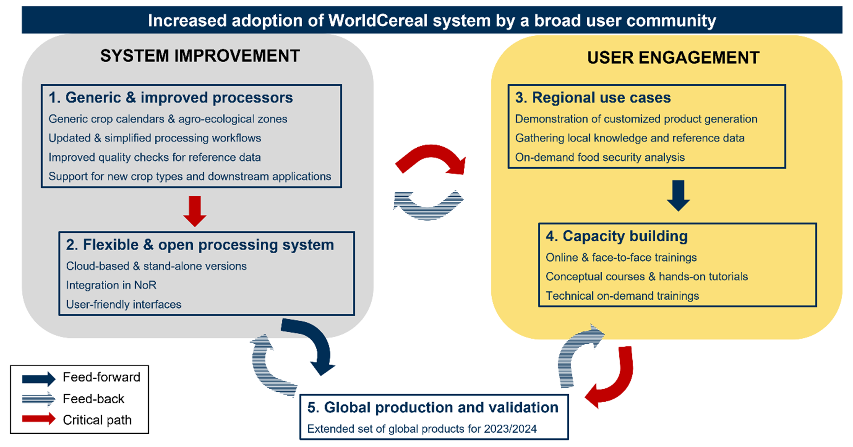
WorldCereal is now entering a new three-year phase, aimed primarily at further upgrading the system and boosting user uptake by the broad agricultural monitoring community. This will be accomplished through a combination of system improvement and dedicated user engagement activities.
 © IIASA
The WorldCereal system will also be integrated into OpenEO – an application programming interface – and implemented as a cloud-based processing service in the new Copernicus Data Space Ecosystem (CDSE). Eventually, it will also be offered through the ESA Network of Resources. On top of that, the WorldCereal crop calendars and classification workflows will be revised to offer more flexibility, allowing the generation of fully customized crop type products.
In addition, at the end of the new project phase, a new series of global cropland and crop type products will be generated and validated, extending the current product suite with eight new crops (sunflower, rapeseed, millet, sorghum, wheat, barley, rye, and soybean).
Finally, during this phase of the project IIASA will experiment with artificial intelligence (AI) to enhance the IIASA Street level Validation Tool, utilized during the first phase. AI will be used primarily for image recognition, helping to identify and separate cropland and specific crops seen on roadside pictures. It is expected that this method will greatly speed up the generation of reference data required to create and validate the produced maps.
Aside from the upgrades to the system itself, the consortium will focus on demonstrating the new system’s capabilities through a series of regional use cases and regularly informing and training the community on the use of the system through capacity building activities, including online webinars, face-to-face training sessions, and Massive Open Online Courses. As part of these activities, the first official WorldCereal webinar will be held in spring 2024 to give potential users an opportunity to learn more about the platform.
This project is the result of a partnership between IIASA, VITO Remote Sensing, the University of Strasbourg, the University of Valencia, Wageningen Environmental Research, and Geo Imaging Satellite (GISAT).
Further information:
https://iiasa.ac.at/projects/worldcereal (Describing the initial phase of the project)
https://esa-worldcereal.org/en (Main project page)
News

03 July 2026
Building bridges: Indian Ambassador visits IIASA
H.E. Ambassador Shambhu S. Kumaran, India's Permanent Representative to the International Organizations in Vienna, recently visited IIASA to explore deeper research cooperation and meet the Institute's Indian Young Scientists Summer Program (YSSP) cohort.
03 July 2026
Tree-Quest: a citizen science tool for collecting single-tree information
Tree-Quest is a citizen science mobile tool that enables users to measure aboveground biomass related attributes (tree diameter, height and species) and estimate carbon stored in trees while contributing data for forest and urban tree mapping, supporting research on biomass and carbon storage. Engaged citizens can measure nearby trees in their local surroundings, such as parks and along the streets in urban areas, integrating science into their daily routines. This helps generate valuable ground-based observations on trees in urban environments that can be used for satellite-based carbon assessment.
02 July 2026
IIASA welcomes delegation from the National Research Foundation South Africa
A delegation from South Africa's National Research Foundation (NRF) visited IIASA to exchange knowledge on systems approaches to disruptive change, innovation, and evidence-informed decision-making. The visit reflects the longstanding collaboration between IIASA and South Africa.