One of the most species-rich rainforests in southern Costa Rica is being digitally recreated. IIASA researcher Florian Hofhansl explains how the project intends to map the biodiversity and health status of the rainforest and attract sponsors.
For more than 30 years, the Austrian Rainforest Association has been collecting donations to save the jungle in southern Costa Rica from destruction. Thousands of hectares have since been bought and incorporated into the Piedras Blancas National Park where the La Gamba research station – a project by the University of Vienna for which I am also part of the steering committee – is located.
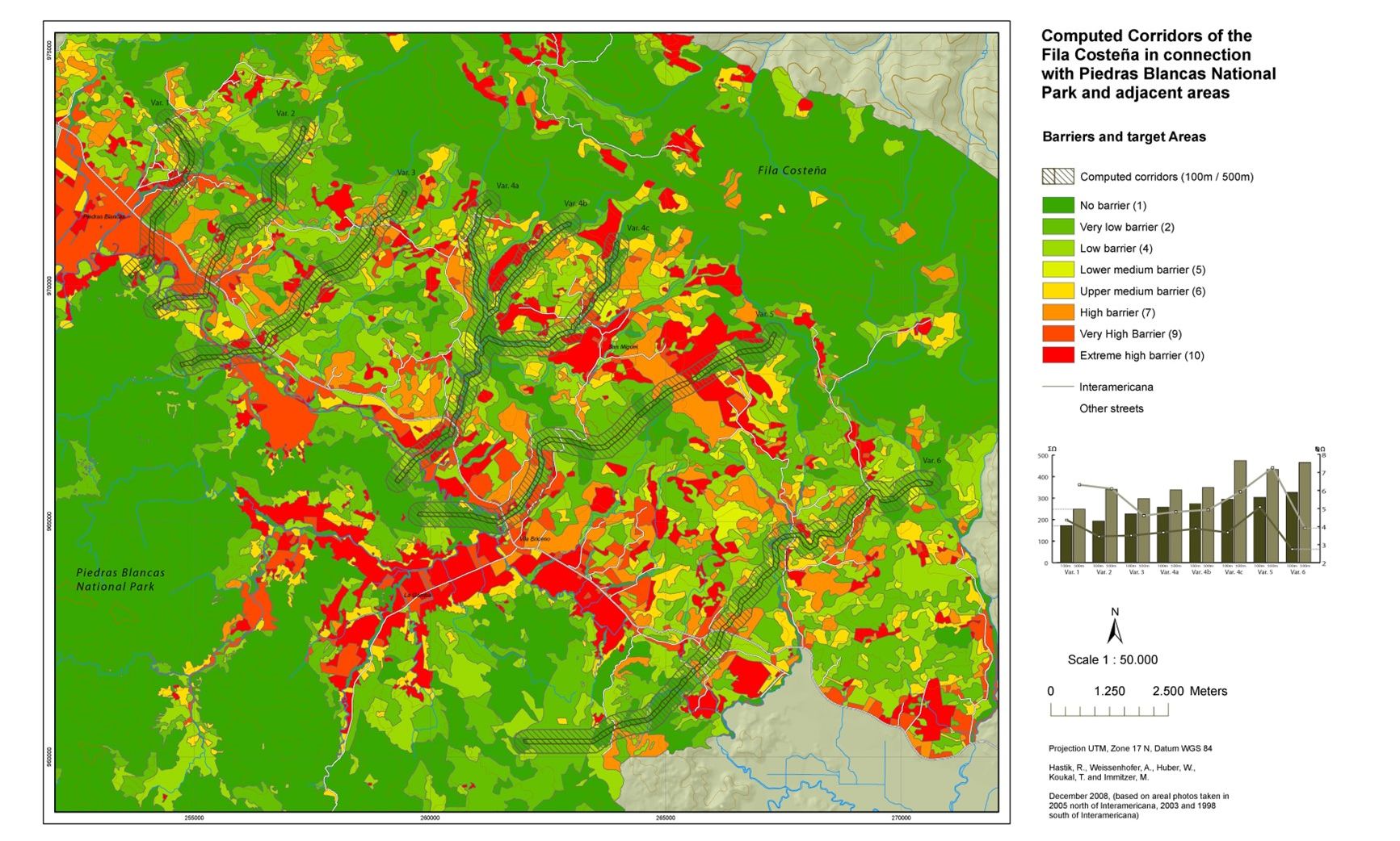
Now the next step is being taken: the national park is to be connected to a nearby mountain rainforest. For this, an ongoing research initiative called COBIGA Biological Corridor, is using the raised funds to purchase fallow land and formerly intensively managed pastures to plant tree seedlings. The aim is to afforest the landscape by connecting patches of forest in an effort to create a corridor for species migration. Nevertheless, additional money will be needed for extending the COBIGA corridor, which aims to connect the lowland rainforests of the Golfo Dulce region with the upland rainforests of the Fila Cal, a mountain range north of the Regenwald der Österreicher.
Potential corridors for species migration across the study region. The image was taken from the website of the COBIGA project and was elaborated in collaboration with the University of Natural Resources and Life Sciences (BOKU), Vienna.
To achieve this, researchers are planting native tree species for assisted reforestation, with the aim of recreating a species-rich forest. Over 100 specially chosen native tree species from the Golfo Dulce region are being cultivated at the model farm before they are planted out. The trees will be monitored for three years, after which time the seedlings should be grown up and big enough to survive without further intervention. After that, the planted area will be left alone to return to primeval forest.
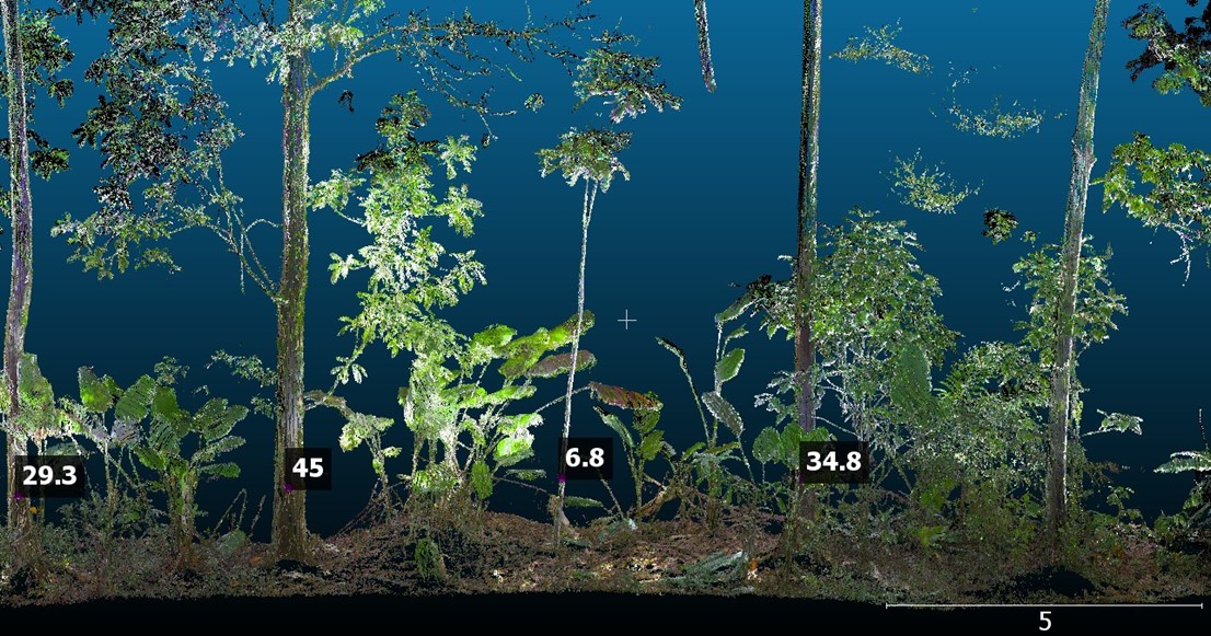
Recently, there has been a boost to these ongoing efforts aiming to restore the landscape by applying assisted reforestation in the region, steered by a project led by the Swedish company R-evolution. The project aims to apply novel remote sensing technologies and will conduct a laser scanning campaign to map the complexity of the rainforest. LiDAR, short for “light detection and ranging”, maps the rainforest by scanning from above using laser scanners attached to an airplane. It creates a precise 3D model of the rainforest’s vegetation structure and plant diversity that is accurate to within three centimeters. In addition, researchers will conduct high-resolution laser scans below the canopy of the trees within the forest to supplement the aerial data.
Through annual measurements, it is also possible to estimate plant growth and track the forest’s development with regard to changes in biodiversity and vegetation structure. Hence, this data will provide an accurate and reliable “digital twin” of the rainforest, allowing a full assessment of its condition.
Point cloud obtained from terrestrial laser scanning of tropical vegetation structure. The values indicate the diameters of stems, which together with the aerial observations of canopy height (see below) may be used to estimate vegetation biomass in the study region.
The idea is that researchers can make use of these novel technologies to take a record of the forest in its three-dimensionality, enabling scientific analysis and exploration of the data. Specifically, the research team plans to make use of the resulting wealth of information on local plant species diversity and vegetation structure to derive parameters for a recently developed trait- and size-structured demographic vegetation model.
[A] Geographic location of the study area and LiDAR transects flown across environmental gradients of the Osa peninsula; [B] Vegetation structure and plant functional diversity observed across permanent monitoring plots; [C] Example for airborne laser scanning (ALS, upper panel) and terrestrial laser scanning (TLS, lower panel) imagery obtained for each transect; [D] Parameters for model simulation of vegetation structure and plant functional diversity.
The IIASA-model Plant-FATE (Plant Functional Acclimation and Trait Evolution) captures the acclimation of plastic traits within individual plants in response to the local environment. It also simulates shifts in species composition through demographic changes between coexisting species, in association with differences in their life-history strategies. Our framework may be used to project the functional response of tropical forest ecosystems under present and future climate change scenarios and thus should have crucial implications for assisted restoration and management of tropical plant species threatened by extinction.
For further information on the project please see the news article (in German), published on ORF (Austrian Broadcasting Cooperation).
Note: This article gives the views of the author, and not the position of the IIASA blog, nor of the International Institute for Applied Systems Analysis.


![- [A] Geographic location of the study area and LiDAR transects flown across environmental gradients of the Osa peninsula; [B] Vegetation structure and plant functional diversity observed across permanent monitoring plots; [C] Example for airborne laser scanning (ALS, upper panel) and terrestrial laser scanning (TLS, lower panel) imagery obtained for each transect; [D] Parameters for model simulation of vegetation structure and plant functional diversity. Figure 4](/sites/default/files/2024-02/Florian4.png)