


The CASHEWS project will enhance agricultural Early Warning Systems (EWS) by evaluating their performance, usability, and integration potential. By comparing existing systems and identifying strengths, weaknesses, and opportunities, CASHEWS aims to guide innovations, support decision-making, and strengthen the resilience of agricultural monitoring.
With changing climatic conditions increasingly affecting agricultural production, there is a growing need for high-performing Early Warning Systems (EWS) capable of anticipating and mitigating risks to food security. Today, a wide range of agricultural monitoring and early warning systems exist, each offering different scopes, functionalities, and levels of user customization.
As the number of monitoring systems continues to grow, there is a pressing need for clear guidelines and comprehensive evaluations to help users navigate and compare these EWS effectively. Assessing systems based on their performance, user-friendliness, and openness can support more informed decision-making regarding which tools are fit for purpose, while also driving innovation and integration across platforms.
The CASHEWS project (Crop Assessment Supporting High-performance Early Warning Systems) builds on the achievements of the WorldCereals project, which aimed to generate global cropland and crop-type products. As a third phase of the WorldCereal project, the CASHEWS project shifts focus from crop type and cropland product generation to evaluating and enhancing the integration and effectiveness of crop type information in existing EWS.
A central objective of CASHEWS is to understand how different EWS perform in predicting and monitoring changing agricultural conditions. The project examines several key points of these systems: their accuracy for predictions, their capacity to assess the impacts of climatic events on agricultural production, and their usability in terms of user-friendliness and (data) openness. Through these comparative analyses, CASHEWS seeks to highlight both the strengths and weaknesses of existing systems and to identify opportunities for better integration across platforms.
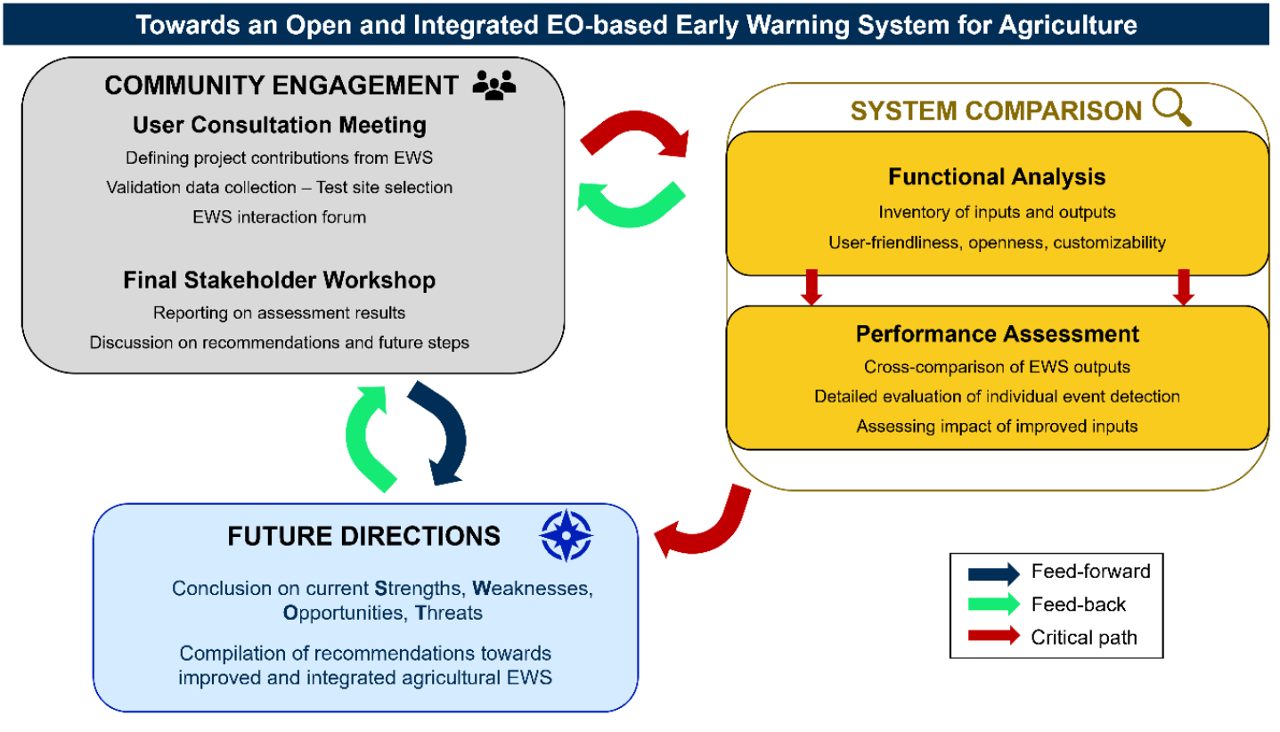
The figure provides an overview of the project showing the main tasks to be performed and their interlinkages. Ultimately, CASHEWS aims to:
 © CASHEWS
- Enable community-wide discussion on essential early warning functionalities, methods for assessing performance differences.
- Compare system properties, functionalities, inputs and outputs for targeted EWS and make a comparison of system performance for specific aspects.
- Assess the strengths, weaknesses, opportunities, and threats that will be used to consolidate recommendations on the current gaps in early warning, and potential ways forward.
In this project, IIASA’s role will be to provide an extensive comparison of the system properties, functionalities, inputs, outputs, and methodologies of a targeted set of global and regional EWS. This comparison and evaluation will feed into a roadmap for the integration of EWS results in the future and provide recommendations for system improvements.
This project is funded by the European Space Agency as part of further developments within the WorldCereals project.
Events
Rome, Italy