


What has been driving recent tropical forest loss? A new Geo-Wiki campaign, starting on December 9th, tries to elucidate the answer.
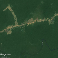 © Brazil. Image Landsat/Copernicus
We are excited to announce that on December 9th we will be starting a new crowdsourcing campaign to help us understand and map the drivers of forest loss across the Tropics. The campaign is part of Indirect Land Use Change (ILUC) project, where IIASA is one of the collaborating partners.
ILUC aims to review the report from the European Commission to the Parliament on the status of production expansion of relevant food and feed crops worldwide (COM(2019) 142), focusing on the quantification of feedstock expansion onto land with high carbon stock, as input for the determination of high ILUC fuels. The Geo-Wiki campaign will contribute to more accurate mapping of the drivers of forest loss in the tropics. This is crucial to guide policies that can protect tropical forests, not only the most biodiverse areas of our planet, but also buffers to the ever-increasing effects of climate change.
As a participant of the campaign you will be asked to do a bit of detective work: Find out what happened to areas that had tree-cover before 2008. Using a combination of very high-resolution imagery, you can figure out what was the cause of the tree-loss. We will aim to classify 150K locations during the campaign, which will launch at the beginning of December.
Mark your calendar and join our campaign, which will include monetary prizes, but also, if you can provide lots of good quality data, you can opt-in to co-write with us a scientific paper describing the findings of the campaign.
The campaign will be very much focused on data quality, so be very careful with your answers so you can get ahead in the game!
Stay tuned for details in our Geo-Wiki Facebook and Twitter feeds. Once the campaign is launched, join it by going to the Geo-Wiki website (https://www.geo-wiki.org), click on Launch and select the Drivers of Tropical Forest Loss branch. You can also click here to go directly to the login page.
For more information on the ILUC project visit our page here and the ILUC project page here (Lot1)
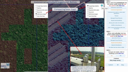 © IIASA
Picture: Detective work in the Geo-Wiki drivers of forest loss crowdsourcing campaign: Using all available tools to answer the questions correctly, e.g. comparing before and after satellite imagery where tree-loss was detected (in red), and using auxiliary sources of information e.g. on-site pictures displayed in Google Earth.
Upcoming Events
Vienna, Austria and online
NODES presenting at EGU 2024
Vienna, Austria and online
IIASA at EGU 2024
Columbus, Ohio
IIASA at the PAA Annual Meeting 2024
Laxenburg, Austria
IIASA-MacroABM 1st Workshop
The Orient Jakarta, a Royal Hideaway Hotel Jalan Jendral Sudirman No. 36, Bendungan Hilir, Kecamatan Tanah Abang, Kota Jakarta Pusat, Daerah Khusus Ibukota Jakarta, 10210
Indonesia COMMITTED Modelling & Stakeholder Workshop 2024
Beijing, China
International Symposium on Polycrises and Systemic risks
Florence, Italy
The State of the Union 2024
Brussels, Belgium
EuropaBON final stakeholder conference
Laxenburg, Austria (IIASA) and Online
MESSAGEix Community Meeting 2024
Virtual (via Zoom)
Water Resources Modeling Summer School: CWatM Level A1
Leuven, Belgium
Joint Workshop on Circular Economy Economic Modelling
Laxenburg, Austria